Late blight Survey Mapper
This is a dynamic, interactive tool for potato late blight surveillance in the Nordic countries. Data are uploaded via a web-based data entry form on the Potato Late Blight Toolbox. The user can select to see one or more countries, - click on the dots to see background data and see all background data in the table below the map.
This is a small single country map without the table with background data, and you can not get attribute data.
The Blight Tracker APP was developed in the frame of EuroBlight – a potato late blight network for Europe, to track early attacks of potato late blight in Europe. In this first version the countries covered are Denmark, Norway, Sweden and Finland. To use the APP you need to be registered as a user. Late blight surveillance is organized nationally or via the EuroBlight Monitoring initiative. After registration the user can login and have access to the following features:
- Report: Upload registration of late blight attack, Where, how much, at which growth stage, production type etc. The user can take a photo and attach to the registration. The location information as latitude and longitude is taken from the GPS on the phone. Only after quality control by a system manager, the sent data will be published on the map. This includes then a delay from sending to display on the map.
- Map: the APP returns a map where late blight is found (currently for DK, NO, SE and FI)
- Infection Pressure: This is implemented for Denmark. The user selects a postal code from a drop down menu. The APP returns a graphics of the infection pressure indicating the weather based risk of attack by late blight including the use of a 7-day weather forecast.
- Unsent Reports: If there is no mobile connection the APP will store the report that will be available under Unsent Reports. When connection is available Unsent Reports can be posted to the system.
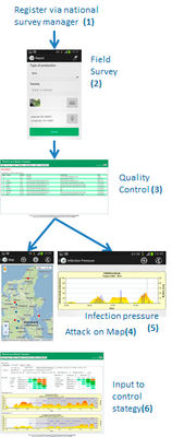
| Step 1. Register via your national survey manager. You will receive User name and password that is required for using the APP. Step 2. Log into the system. Select REPORT and use the Blight Tracker to report your observations: Field name, level of attack, growth stage, field type, take a photo, press include GPS and press Send. If you have no contact with the mobile network, the APP will store your report in Unsent reports. You can send the report when you return to an area with mobile network coverage Step 3. When your report is stored in the Database, it will by default be marked as unpublic until your national survey manager has quality-controlled your data and then marked the report as public. Step 4. Select MAP and see a Google map with public observations Step 5. Select INFECTION PRESSURE and then search on postal code region names to get a graphics of the late blight risk indicated by the infection pressure. Step 6. |